Flood Risk Management
Get real-time warnings of potential floods so you can protect your people and assets, while minimizing disruption to your operations.
Get real-time warnings of potential floods so you can protect your people and assets, while minimizing disruption to your operations.

INTERACTIVE REPORT
Learn the six keys to building and maintaining a strong flood warning system and connect with three real-world success stories that illustrate our approach.

We provide real-time data you can count on – with accurate measurements to drive decisive actions.

Set your own rules to trigger alerts or a team response after a set amount of rainfall or other conditions.

Hardware designed for minimal maintenance, even in the harshest environments.
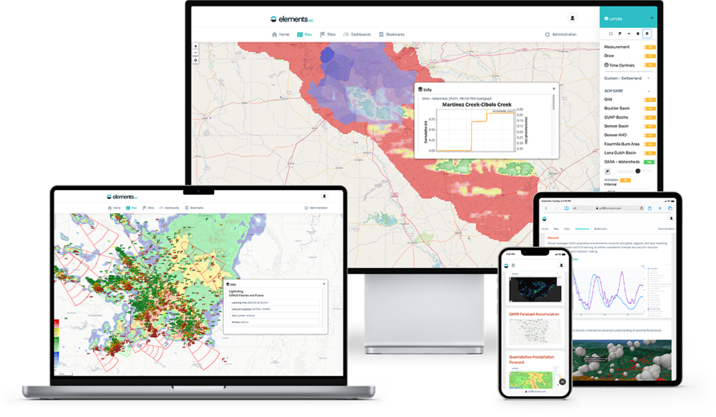
Situational Awareness
Real-time data. Rainfall estimates. Alert protocols. Everything comes together in our software platform. Built on open protocols, it works with whatever hardware you choose to use. More than 75% of all flood warning systems in the U.S. use our products or services.
A centralized data source facilitates the assessment of existing infrastructure for its resilience against flooding events. By analyzing the consolidated data, authorities can identify vulnerable areas and develop targeted rehabilitation plans. This approach ensures that limited resources are efficiently allocated to strengthen critical infrastructure, reducing the risk of damage during floods.
Consolidating weather and flood monitoring data into a single source also allows urban planners and designers to access accurate and comprehensive information. This enables them to make informed decisions when constructing or upgrading infrastructure, such as roads, bridges, and drainage systems. By incorporating reliable data, cities can better adapt to changing climate conditions and mitigate potential flood risks.

rugged instrumentation
A complete, integrated flood monitoring system includes all the remote site hydro-meteorological sensing instrumentation, communications equipment, central base station equipment, as well as data collection, archiving, processing, and management software designed for flood warning.
Real-time weather data provides essential information on intense or prolonged rainfall, rapid snowmelt, abnormal rise in seawater level, and excessive and rapid rainfall events. By monitoring these conditions, authorities can detect potential flood threats and issue timely warnings to communities in vulnerable areas.
With access to real-time weather data, authorities can send flood warnings to communities in threatened areas promptly. These warnings enable residents to prepare and take necessary precautions, such as evacuation or fortifying their properties. The availability of real-time data ensures that warnings are accurate and tailored to specific locations, maximizing their effectiveness.
Real-time weather data is indispensable before and during a flood. It helps identify impending flood conditions, aids in planning and designing flood warning systems, enables timely warnings to communities, enhances preparedness and response efforts, identifies high-risk areas, and optimizes dam and reservoir operations. By leveraging the power of real-time weather data, communities can better protect lives, safeguard property, and improve overall flood resilience.

flood warning system
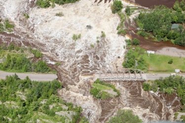
Flooding is the most common and widespread of all weather-related natural disasters and is a threat in every part of the world primarily where rainfall occurs. With more people in the world at risk today from flooding than ever before, being prepared for floods is crucial to decrease negative effects of flooding in our communities.
Our range of tools help you take preventative measures against potential flooding and implement effective response plans. Additionally, they help you detect early signs of flooding and take decisive action to protect people and assets.
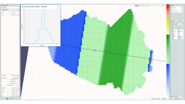
PREPARATION & ASSESSMENT TOOLS
Our Storm Builder helps clients correctly apply dynamic design storm characteristics and achieve valid, reproducible hydraulic modeling results. That means we can help you understand how a storm of any scale, size, or type would impact your local area.
Through storm modeling and simulation, it is possible to predict the extent of flooding in different scenarios. By inputting various rainfall intensities and durations into computational models, experts can estimate the resulting water levels and potential flood areas. This information assists emergency managers in developing evacuation plans, allocating resources, and implementing preventive measures, ultimately reducing the impact of floods on communities.
Analyzing past storm data in combination with computational modeling allows for improved flood prediction. By creating “what if” scenarios and running simulations based on historical rainfall patterns, experts can refine flood prediction models. This iterative process enhances the accuracy and reliability of flood forecasts, providing advanced warning time for residents and enabling proactive response actions.

AEM Elements 360 is a multi-hazard weather intelligence solution and the cornerstone of the Elements Resiliency Platform.
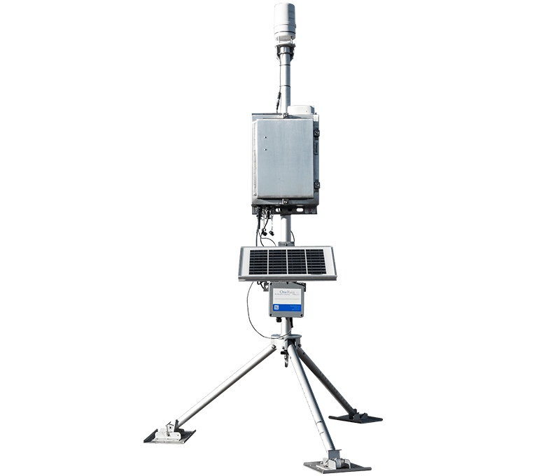
An easily deployable automated all-in-one early warning system for remote real-time environmental, weather, and hydrologic monitoring.
Robust and reliable TDMA radio communications that transmits your data to where it’s needed.

Our unique approach of combining rain gauge and radar data delivers a more accurate rainfall measurement.

Improve your modeling with collated rainfall data – historical and real-time – from across the United States.

Our experts help you find the perfect mixture of sensors, gauges and other tools to optimize water management in your location.

Tell us the conditions you need to monitor, and our experts will build the right system for the job.

Tools and services to help you accurately track rainfall and model incoming storms.
A flood warning system is an early flood monitoring solution that deploys accurate and well-maintained sensing instruments, like rain gauges, water level sensors, and flow rate sensors. The data from these sensors then utilizes a reliable and robust communications systems and a central base station to allow the data to be processed, analyzed, and monitored. When a threshold is reached across any of the sensors, an automated alert is sent out to initiate emergency action plans.
Locally owned and operated automated flood early warning systems help save lives and reduce property damage by providing critical, real-time information to the National Weather Service and public officials at all levels of state and local government to issue alerts warning people who are vulnerable to flooding.
To begin your flood planning, a flood risk analysis should be completed, evaluating the risk of flooding and the vulnerability of the specific area. Things that need to be taken into consideration are topography, infrastructure, climate, frequency of storms over an area, and more. Read our Flood Resilience and Planning Solutions Guide to learn more.
Hydrological forecasting provides flood inundation mapping enabling advanced lead time to flooding conditions and indicates which areas might be impacted with flooding conditions.
Levees, designed to protect communities against flooding, can be particularly vulnerable during intense storm events. Heavy rainfall can put levees at risk of overtopping and the consequences can be catastrophic. Additionally, deterioration and failure due to erosion is of particular concern for communities living near or behind a levee. During high water events, erosion can take place at or below the water surface. Even if a levee is being patrolled during an event, unseen erosion can be threatening the levee’s structural integrity.
Wildfires cause serious damage to property and communities. With vegetation gone, rainfall can cause debris flows and flash floods. With fires that burn hot, the soil can become hydrophobic, increasing runoff and the potential for dangerous flooding, debris flows and landslides. With remote
difficult terrains and lack of communications infrastructure, monitoring for potential flood threatening conditions can be challenging.
OneRain implemented the ALERT2 protocol to achieve higher data quality.

Learn how Contrail® provides a one-stop flood protection toolkit for a community of over 1,000,000.

See how the Bureau of Indian Affairs collaborates with Tribal Nations to monitor conditions at more than 140 dams across the country.

Doña Ana County leverages real-time hydrology and lightning data to gain situational awareness and make decisions to support emergency management operations when flooding is imminent.

Raleigh saw a need to proactively anticipate flood conditions before they happened, and in areas that had limited rain gauge coverage. They partnered with AEM’s Vieux & Associates brand to help make that vision a reality.

To maintain real-time awareness of dynamic flood conditions, Santa Barbara County’s Flood Control District maintains a public-facing website powered in part by AEM’s Contrail platform.

REPORT
For many communities and organizations, flood risks continue to rise. AEM’s 2022 State of Flood Risk Management Report gives you the latest thinking from the professionals who are responsible for managing these risks. The report draws on survey responses from professionals across the globe who work for a wide range of organizations spanning both the public and private sectors. Get insights on the following:

solution guide
In this solution guide, you’ll learn how to better prepare, design, and plan for flooding events, improve resiliency, and employ technologies that help protect lives and property, including:

WEBINAR
The growing frequency and intensity of flood events around the world have driven the need for more accurate forecasting and real-time hydrologic simulation. A predictive flood modeling system can provide information necessary about flood timing and intensity for critical decision-making during an event, both forecast and in real time.


