Levee Safety: New REMS product makes it possible to remotely monitor sites at risk for erosion failure

GRASS VALLEY, CA — High Sierra Electronics announced REMS™ — a new innovative Remote Erosion Monitoring System for earthen levees and embankment dams that is designed to detect when and where erosion has occurred and automatically alert and send information to the levee and dam owners, operating managers, and local public safety officials.

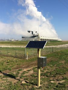
The new automated levee erosion detection system uses a network of beacon sensors that are embedded at levee system or embankment dam sites that are identified as at risk for erosion. If erosion occurs and washes the bank away, the beacons immediately transmit their status. All beacon and site data is managed in Contrail® cloud-hosted monitoring software where users can keep track of the REMS site status. Changes in beacon status can send custom alert notifications to varying stakeholders via e-mail, SMS, or text.

HSE Remote Erosion Monitoring System for Levees and Earthen Dams
Richard Marck, a retired Levee Superintendent for the American River Flood Control District, shows one of the REMS beacons being used for the California Department of Water Resources-funded Levee Safety project on the Sacramento River.

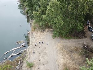
The REMS is being tested for the first time for a Levee Safety project, funded by a CA DWR Grant, on the Sacramento River 35 miles north of Sacramento, in a multi-agency collaborative effort to help detect erosion early and alert the levee owners. The sites chosen for the project are at vulnerable locations along the river where erosion occurs very quickly.

“We developed REMS to address one of the major safety risk factors associated with levees, and that’s erosion and the potential for levee failure and flooding. With increasing populations in leveed areas, the lives and property of those living behind the levee can be at great risk,” said Tom Ogden, Product Manager. “At High Sierra Electronics, our expertise for the past 29 years is real-time monitoring using sensors and telemetry. We put these to use in public safety and warning systems and we looked at how we could apply similar technology in this application where there are clearly some major risks,” he explained.

Most of the nation’s levees are earthen embankments constructed of sand or soil which can erode easily due to the long-term effects of seepage and saturation, overtopping, and fast-flowing water. While today’s new levee systems are designed and constructed to high engineering performance standards and guidelines established by the U.S. Army Corps of Engineers, many existing levee systems were not built to current standards. Adding to the risk is the aging infrastructure — the average age of levees in the U.S. is 50 years. These levees require regular inspections, maintenance, upgrades, and patrolling for high water. Levee erosion becomes a huge challenge to monitor, often not visible and missed because of what’s going on below the surface. As the levee systems get older, inspections and maintenance become more challenging.

Overhead view of High Sierra Electronics' REMS Levee Erosion Detection System on Sacramento River
Overhead view of installation of High Sierra Electronics’ REMS Levee Erosion Detection System on Sacramento River.

“We believe REMS to be a really cost-effective solution that will make it possible to monitor potential levee erosion sites 24×7 and alert key personnel about problems early so they can take timely action,” added Ogden.

There are estimated to be about 100,000 miles of levees in the U.S. Two-thirds of the U.S population are in counties that have at least one levee. Thirty thousand miles of levees are documented in the National Levee Database, with 97% of these earthen levees. The U.S. Army Corps of Engineers has responsibility for over 14,000 miles of levees under its Levee Safety Program. A further estimated 85,000 miles of levees are privately owned and operated.

In the last five to six years, the Army Corps has conducted inspections of levees under its Levee Safety Program. With about half of them inspected today, the Army Corps reports that 20% are of moderate- to higher-risk, with bank erosion considered one of the top three risk factors.

REMS is aimed at local levee owners, levee safety authorities, levee stakeholders, states, local governments, tribes, and private entities. Learn more about REMS, Remote Erosion Monitoring System for levees.


About High Sierra Electronics, Inc.
Established in 1992, High Sierra Electronics, Grass Valley, California, has been designing and manufacturing environmental monitoring systems for the protection of lives and property. High Sierra Electronics’ systems help identify threats posed by the weather, which include flooding, dangerous road conditions, and vulnerable dams and levees. High Sierra Electronics is part of Advanced Environmental Monitoring (aemonitoring.com), a family of innovative companies whose technologies enable decision-makers to improve their reaction time to weather and environmental events, helping to protect communities, people, and infrastructure. For more information, visit www.hsierra.com or phone 800-275-2080.

New Orleans Installs New High Sierra Electronics’ Flood Warning System

The City of New Orleans has installed a new automated Flood Early Warning System comprising High Sierra Electronics’ sensors, weather stations, and roadway warning signs. The High Water Detection Systems (HWDS), installed at 12 underpasses throughout the City, continuously monitor rainfall and water level data in real time and are designed to improve public safety.

Advanced High Water Detection System Monitors Around the Clock

Motorists often underestimate how quickly and deep the water can get at the low-lying underpasses.

It doesn’t take much rain for the underpasses in the City to flood during heavy or sustained rain storms. Motorists often underestimate how quickly and deep the water can get and can find themselves stuck when their vehicle stalls out in high water. All too often, first responders and emergency crews have had perform water rescues at these underpasses.

The new advanced warning system detects and monitors real-time rainfall and rising water conditions around the clock in each of the high-risk areas. As certain conditions and thresholds are exceeded, the system automatically triggers “road closed” signage and beacon warning lights to alert drivers to the flooding hazard. Data from the various sensors and weather stations are continuously collected 24/7 by Contrail® web-based software. As well as providing visualization to City personnel, the software automatically processes, analyzes, and monitors this information for potential flooding and sends automatic alerts and detailed notifications to relevant City personnel and emergency responders to give them advance warning of impending flood conditions.

High Water Detection Warning Sign
New automated High Water Detection and Flood Warning System includes “Road Closed” signs and flashing beacons during roadway flooding events to warn motorists

Beyond warning motorists to turn around, the flood warning system will also provide an additional layer of critical, real-time information to the New Orleans Office of Homeland Security and Emergency Preparedness (NOHSEP), the Sewerage and Water Board of New Orleans, and the National Weather Service during storms. Each installation includes a weather station that measures the real-time rate of rainfall, rainfall total, temperature, and wind speed at the underpass location.

“Impacts from storms can be highly localized,” said NOHSEP Director Collin Arnold. “Having twelve calibrated weather stations spread throughout the city will give our emergency managers and our drainage partners significantly more situational awareness to make critical and timely decisions during storms.”

Road closure data from the flood warning system will also eventually be displayed publicly on the City’s real-time road hazard website, streetwise.nola.gov, enabling motorists to plan ahead.

The system is scalable, so as funds become available, additional locations of frequent street flooding will be considered for installation.

More on this story can be viewed on the City of New Orleans website here.

Video: Watch WWL-TV coverage of new flood warning system for City of New Orleans


Contrail® is a registered trademark of OneRain Incorporated, a sister company of High Sierra Electronics, Inc. High Sierra Electronics and OneRain are part of the AE Monitoring family of innovators.

Flooded Road Safety – New High Water Detection System for City of McKinney Texas

The City of McKinney, Texas, will install an automated High Water Detection System (HWDS) in areas close to Wilson Creek that have a history of flash flooding. During heavy or sustained rainfall events, water in the Wilson Creek rises rapidly causing several roadways in the City to flood with little or no warning. The new HWDS system, designed by High Sierra Electronics (hsierra.com), collects data in real time from several water level sensors and then triggers flashing lights to signal to motorists that it’s dangerous to cross the road. The move by the City is to help improve public safety by providing advance warnings to motorists and pedestrians that flooding is imminent or occurring. The project is in cooperation with the North Central Texas Council of Governments (NCTCOG) and the Texas Water Development Board (TWDB).


Driver safety during roadway flooding is of great importance. Since 2015, the City’s emergency management team has made five rescues where vehicles on these roads have been swept away in the water caused by road flooding.

The High Water Detection System (HWDS) solution, comprising water level sensors, flashing lights and signage, will be installed at five points along two roads near the Wilson Creek. The system is fully integrated for 2-way communication with Contrail software by OneRain, to track the rising waters and help emergency responders and City public works staff to make better decisions about potential flood risks. As the water rises to pre-determined levels, the signs and flashers will activate to warn drivers and pedestrians about the potential of flooding or that it is happening.

Data from the HWDS, along with other regional data, will be accessible to the public via Contrail online portal where users will be able to check the status of the roadways prior to traveling.

See more on this news with a report by Ben Russell, NBC5 News, Dallas-Fort Worth

About High Sierra Electronics
High Sierra Electronics was founded in 1992 and is headquartered in Grass Valley, California, with additional offices in San Antonio and Fort Worth, TX, and Louisville, KY. High Sierra specializes in flood warning sensors, equipment, and transmitters for public and improved traffic safety. For more information visit www.hsierra.com.

#floodwarning #hwds #roadweather #lowwatercrossing #roadflooding #texasflooding


Driver Safety During Roadway Flooding

Safe to Proceed: Roadway Flooding Solution

Author: Frank Gutierrez, Regional Sales Manager at High Sierra Electronics, Inc. for South Central/Southeast U.S.A. 


Flooding causes more deaths and property damage in the U.S. than any other severe weather related event¹. The reason that so many people drown during flooding is because few of them realize the incredible power of water. A mere six inches of fast-moving water can knock over an adult. It takes only two feet of rushing water to carry away most vehicles, which includes pick-up trucks and SUVs.


Texas is prone to extremely heavy rains and flooding with half of the world record rainfall rates (accumulations in 48 hour less). It also has the distinction of being the state with the most flood-related deaths in the past thirty-six years. Bexar County in Central Texas, about 190 miles west of Houston, is particularly vulnerable because storms stall along the Balcones escarpment. This region has earned the nickname “flash flood alley”. Due to this geography, floods are a natural hazard and a regular occurrence.

In order to better prepare residents, Bexar County officials implemented a High Water Detection System (HWDS) in 2007. The High Sierra Electronics, Inc. (HSE) system has evolved over the years and now includes more than 100 sites. It uses a combination of rainfall and water level gauges to monitor conditions at low points on the roadways. When water rises to a pre-determined unsafe level, the sensor(s) automatically trigger flashing beacons and/or barrier gates. The system is solar powered and works during power outages (i.e., extreme weather events). The system provides control even in remote locations and County officials can receive text or email alerts when the system is activated.

Bexar County Texas Macaway High Water Detection System (HWDS) by High Sierra Electronics, Inc.


Information from the HWDS feeds a Bexar County public web site known as HALT, High Water Alert Lifesaving Technology. The HALT system is a tool used to warn drivers when there is too much water over the roadway to help prevent a potential drowning disaster. The public is encouraged to visit https://www.bexarflood.org/#!/main/map where a map displays current flood information and emergency road closures. More specific information can be obtained by clicking (highlighting an area) on the map or entering a location. Alerts via a Twitter feed are also available.

Likewise, the City of San Antonio (within Bexar County) has implemented their own program known as SAFE, San Antonio Flood Emergency. The City emphasizes being prepared, being informed, being safe. They utilize HSE’s HWDS in the same manner with flashing beacons and automatic barrier gates. In neighboring Comal County, HSE was awarded a contract in 2010 for a similar project involving the installation of more than thirty stations. Plans are currently underway in coordination with the City of New Orleans’ Office of Homeland Security and Emergency Preparedness (NOHSEP) to deploy 24 stations with flashing beacons in August 2018.


(1) NOAA National Centers for Environmental Information (NCEI) U.S. Billion-Dollar Weather and Climate Disasters (2018). https://www.ncdc.noaa.gov/billions/


About High Sierra Electronics
High Sierra Electronics was founded in 1992 and is headquartered in Grass Valley, California, with additional offices in San Antonio and Fort Worth, TX, and Louisville, KY. High Sierra specializes in flood warning sensors, equipment, and transmitters for public and improved traffic safety. For more information visit www.hsierra.com.


Fog Warning System for Illinois Power Plant

Fog is a Common Phenomenon at Illinois Power Plant


High Sierra Electronics completed the installation of  a visibility warning system at a power plant in southwest Illinois.

High Sierra Electronics and Traffic Control Corporation partnered together to solve an interesting problem at the Prairie State Energy Campus near Marissa, Illinois. When the conditions are right, localized dense fog forms along County Road 12 adjacent to the power plant. In many cases, the fog formation results because of added water vapor from the power plants steam vents. This causes low visibility and dangerous driving conditions for the public. It was decided that a warning system needed to be put in place to warn the traveling public to fog along the roadway.

The system designed uses a minimalist approach utilizing highly accurate and dependable equipment to provide a low cost system that will work for years to come. The warning system consists of six evenly spaced visibility sensor stations and two sign stations located on either end of the problem area along County Road 12.

The visibility sensor stations utilize the HSE Model 5434 visibility sensor to send a signal to the TCC provided radio when a low visibility threshold is met. An LED mounted to the bottom of each visibility sensor station cabinet alerts the system administrators which station triggered the alert. The solar system and flashing LED is controlled by HSE Model 5315-01 MPPT Solar Charger and Load Control.

The sign stations consist of a flashing beacon sign and a LED sign to warn motorists of fog conditions ahead.  A signal is sent to activate the sign stations when fog is present at any of the visibility sensor stations.

To learn more about the system described or if you have a similar application please contact High Sierra Electronics at 800-275-2080.


#fogwarningsystem #roadsafety #roadweather

Guadalupe River Flood Siren System Project

High Sierra Electronics was awarded a project to improve the Guadalupe River Flood Siren System.  The project is a cooperative effort between The Water Orientated Recreational District of Comal County, the City of New Braunfels, Comal County’s Engineering Office, and Guadalupe County.  In addition to river gauge stations, the system includes several warning sirens that will automatically activate when the water level rises to a pre-determined unsafe level.